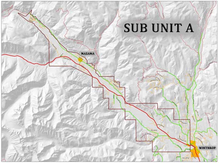
Sub-Unit A stretches from Winthrop to the end of Lost River Road, and includes the Early Winters, Wolf Creek and lower Rendezvous areas.
Mazama Advisory Committee presents draft document
About two dozen people gathered at the Mazama Community Club on Sept. 15 to discuss the future of land use in the upper Methow Valley.
The Mazama Advisory Committee (MAC) presented a draft Community Comprehensive Plan Update for the area known as Sub-Unit A for public review and comment. The draft is based on two years of work by members of the MAC, including community outreach that began in 2024.
According to the draft Update, “Sub-Unit A encompasses lands extending northwest of Winthrop town limits to the end of Lost River Road and extends west to include the Early Winters area. Wolf Creek and the lower Rendezvous are also included in Sub-Unit A, along with some isolated ownerships such as mining claims.”
Planning specific to Sub-Unit A dates back to the 1970s, when residents recognized that the qualities they prized were at risk in the face of population growth and land development.
A history
The opening of the North Cascades Cross State Highway and plans for creation of a destination ski resort near Mazama were two factors that motivated efforts to protect the Methow Valley’s natural beauty and quality of life.
Residents representing a range of interests formed the Methow Valley Land Use Advisory Committee, which drafted the Methow Valley Plan. The plan established land use policies for lands throughout School District 350, which encompasses the Methow Valley as far south as Gold Creek.
The area was later classified by Okanogan County as the Methow Valley More Completely Planned Area (MVMCPA).
The county’s Board of Commissioners adopted the Methow Valley Plan as an addendum to the Okanogan County Comprehensive Plan in 1976. According to the update, “The Addendum recognized the Mazama area as one of the ‘prime targets of development’ and identified Sub-Unit A as ‘the unit closest in proximity to potential future development’ and ‘most environmentally fragile’.”
In the 1980s, states the update, “Mazama area residents sensed a need to develop more specific guidelines for growth in the MVMCPA planning area and particularly in the Mazama/Early Winters area, triggered by the Early Winters destination ski resort proposal.” The MAC began work on a master plan for sub-Unit A. That plan was adopted in 1989 and revised in 2000.
Current vision
The current update is intended to address the community’s vision and values and to reflect changing conditions that could affect the upper valley and residents’ way of life. It’s also intended to be easier to follow than the current plan. Rather than edit and re-organize, said MAC member Claire Bunney, the committee re-wrote the plan, using modern language and addressing topics of special interest to community members.
The update includes goals and policies on a range of topics related to land use. The plan states that “The MVMCPA Sub-Unit A Goals represent strongly held community values, and Policies provide framework for attainment of the Goals for each Plan element.”
Under the heading “Planning Expectations,” the update states that “Sub-Unit A embodies unique characteristics, and appropriate planning for inevitable growth and development is necessary. Limited commercial development and affordable workforce housing are vital to the economic well-being of our community. However, preservation of the attributes that make Sub-Unit A home to its residents is key — the open spaces, views, quiet [starry] nights, neighborliness, a slower pace, and mutual respect for both people and property are why those who live here call this home.”
“The goal is to make it so there is not a big change,” said MAC member Casey Smith. What the MAC heard from the community is that residents like the upper valley and would like to maintain it as it is, he said. Smith and the other four members of the MAC — Bunney, Jim Gregg, Karen Reneau and John Sunderland — have worked to create an update that reflects community input. As such, he said, Smith does not expect the update to be controversial.
The process
Okanogan County Planning Director Stephanie “Pete” Palmer attended the community meeting and outlined the process by which the update will be considered for adoption by Okanogan County.
Once the MAC has a draft ready for county review, it will be submitted to the county. Planning staff will evaluate the draft for “consistency with the county comprehensive plan, county policies, regulations, infrastructure, environment, and applicable state law” according to a handout that Palmer distributed.
The county will then conduct an environmental review of the update and prepare documentation as needed, in accordance with the State Environmental Policy Act (SEPA).
Following environmental review, the update will be referred to the Okanogan County Planning Commission for review and recommendation. Public notice and one or more hearings will follow.
Ideally, said Palmer, the Planning Commission will be willing to hold a hearing in the Methow Valley. Once the commission has developed recommendations, it will forward them to the county commissioners for consideration and legislative action.
The commissioners may adopt the proposal or may modify it, opening another round of review. Once adopted, the update will be incorporated into the county’s comprehensive plan.
Gregg acknowledged that some of the proposed changes to the current plan may be “a hard sell to the county.” Being able to say “this is what the community is saying” will enhance the update’s prospects when it is presented to the Planning Commission, and a local hearing will allow the commission to experience the extent of local support, he said. Gaining acceptance by the county commissioners may be more difficult, he said.
During the community meeting, MAC members offered a brief overview of the update, and presented several specific topics for public comment. Those were topics that the MAC members heard community members wanted to add or substantially change, said Sunderland. They included light and glare, including dark skies; drone use; clearing and grading; a planned-development requirement for division of larger parcels; limits on house size; ridgeline development; wildfire preparedness; tourist-related development and marketing; and ATVs.
Community members added comments to chart-pad sheets designated for each topic and discussed thoughts and ideas with MAC members. Bunney said the MAC’s intention is to “take the feedback, go back to the draft plan, and make sure we got it right” — accurately representing the community’s wishes based on the MAC’s two years of outreach.
“We will make final edits to better capture our learning” following the meeting, she said, and “may come back to the community, depending on the extent of the comments,” Bunney said.
Once edited, the update will be ready for submittal to Okanogan County. By involving the county early in the update process, MAC members hope to smooth review and approval.
Nevertheless, the timeline for adoption of the update is hard to predict, said Palmer, as it depends on variables related to staff review time and the responses of the Planning Commission and the county commissioners. Once the public comment process is initiated, action may be anticipated in 60-120 days.
The update will provide the policy basis for any changes to the county’s development regulations that are needed to implement the plan. Following adoption of the update, amendments to regulations such as the zoning code and subdivision standards will require a separate process, including review by the Planning Commission and action by the commissioners.


